


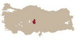
North : 38°43’9.47″N South : 37°31’1.57″N East : 41°18’54.10″E West : 39° 7’6.53″E Location: South East Anatolia is in the south-eastern corner of Turkey, bordering Iraq and Syria. Climate: Rough and dry terrestrial climate is dominant in the Diyarbak›r province. Very hot during the day and cold at night during growing season. Precipitation differs between 600 – 1000 mm with an average of 750 mm per year. The longterm mean [&hellip
North : 40°55’34.54″N South : 37°53’2.99″N East : 40°22’58.61″E West : 35°27’45.19″E Location: Mid-Eastern Anatolia is located in the east of Turkey. Tokat is at the northwest corner of this area which is close to the Black Sea. Elaz›¤ and Malatya are located nearer to the southeast of Turkey. Climate: The dominant climate in Elaz›¤ and Malatya Provinces are the terrestrial climate and the winter seasons pass cold and precipitant [&hellip
North : 40°45’26.49″N South : 38°12’49.75″N East : 33°37’51.75″E West : 28°44’6.22″E Location: Mid Northern Anatolia consists of the two separate regions of Ankara and Uşak. Uşak is in the west of the region and Ankara is the more north-eastern part of the region. The Mid Northern region is the heart of Anatolia right in the centre of Turkey. Climate: Hot dry summers and cold winters. It has a continental [&hellip
North : 39°23’5.36″N South : 38°19’34.09″N East : 35° 4’40.66″E West : 34°14’41.79″E Location: Mid-Southern Anatolia is surrounded by Kayseri, Kırşehir, Aksaray and Niğde. Climate: Hot dry summers and cold winters. It has a continental climatic character. Cappadocia has a steppe climate, there is a great temperature difference between day and night. It is cooler and drier than in the popular tourist areas of the Mediterranean and the Aegean coasts. [&hellip
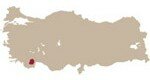
North : 36°55’20.97″N South : 36°27’5.37″N East : 30°14’28.52″E West : 29°39’44.31″E Location: Mediterranean region is the south part of Turkey facing the Mediterranean Sea. Climate: Typical mediterranean climate with hot summers and mild winters. It has a maritime climatic character. Precipitation differs between 400-600 mm with an average of 500 mm per year. The longterm mean temperature differs between 12 to 16°C. Soil type: Differs from pebbly clay loam [&hellip
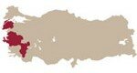
North : 40°43’41.81″N South : 36°51’4.99″N East : 30° 5’10.61″E West : 25°59’53.50″E Location: The Aegean region is the western part of Turkey facing the Aegean Sea and Greek Islands. Climate: Typical mediterranean climate with hot summers and mild winters. It has a maritime climate in coastal parts (vineyards are at an altitude of 150 metres, and are closer to say Bari or Athens) and continental climatic conditions (in the [&hellip
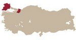
North : 42° 5’58.62″N South : 40°14’37.61″N East : 31° 1’21.16″E West : 26° 2’23.22″E Location: Marmara designates a region spread over southern Bulgaria (Northern Thrace), northeastern Greece (Western Thrace), and northwestern Turkey. Marmara has borders on three seas: the Black Sea, the Aegean Sea and the Sea of Marmara. Climate: Typical mediterranean climate with hot summers and mild winters. It has maritime climaticconditions. Precipitation differs between 400 -1000 mm [&hellip